Nutriad’s Weather-Mycotoxin Report
Published: August 21, 2018
By: Guilherme Bromfman, Director of Business and Product Development at Nutriad
Reports around the country are indicating an average of 70% of corn between good and excellent conditions.
A very dry month of July in parts of the Midwest and Southern Plains could have a negative impact on yield, once corn was in blister and milking stages, in which moisture is critical.
Most of the corn are moving now from milking stages to dough stages. While most of cell division is done at milking, there is still growth potential due to starch accumulation, meaning that weather stress can still influence grain quality and yield.
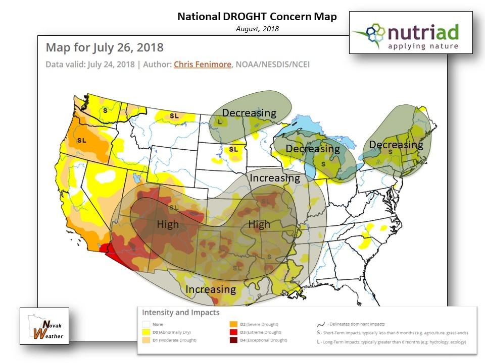
As mentioned in previous reports, a high temperature combined with drier conditions as we are seeing in parts of the Midwest and the Southern Plains, can become not only a yield problem but also a mold and mycotoxin issue.
Weather patterns as noted in those two regions are favorable to Aspergillus flavus and Fusarium verticillioides, which can produce Aflatoxins and Fumonisins, respectively.
The dough stages are critical to grain quality and mold contamination, and as we progress to those phases in the following weeks, Nutriad will keep you informed with our monthly weather and mycotoxin report.
NUTRIAD’S United States 30 Day Outlook (August 2018)
Author: Thomas Novak of Novak Weather Consultants
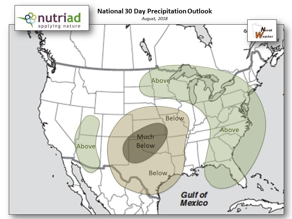
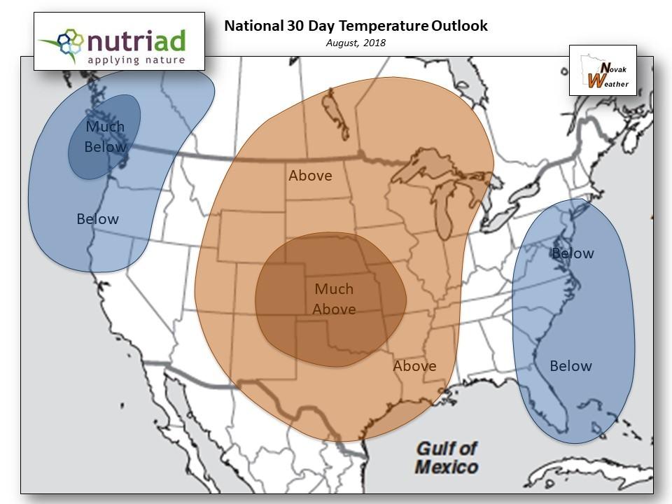
United States:
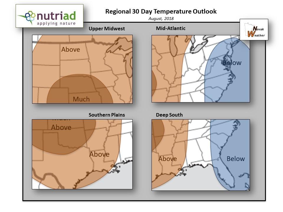
In general, the Jet Stream steering winds will surge onto the northwest coast of the U.S. and continue northeast into Canada before diving south towards the Atlantic coast of the U.S. This jet stream pattern will likely bring HOT conditions for much of the U.S. as a large ridge builds over the heart of the country. Cooler than average conditions are expected on the coasts, especially the Pacific Northwest and southeast Atlantic Coastal region.
As the late summer ridge builds over the central U.S., DRY conditions will develop under the upper level high pressure system that anchors over the heart of the country. In turn, the storm track will get pushed north into southern Canada as the Plains states bake under the dry heat. Meanwhile, it appears that portions of the eastern U.S. will experience wet conditions, especially during the first two weeks of August.
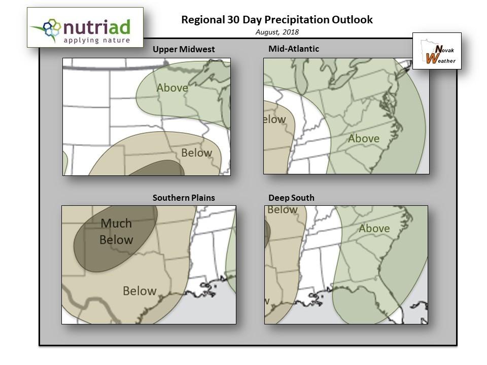
Upper Midwest:
Concerns are growing as the beginnings of a drought develop, especially over the eastern sections of this region including portions of MN, WI and IA. Most of this region will be warmer than normal with temperatures often surging well into the 80s & 90s. Don’t be surprised if some areas reach and/or exceed the 100° figure, especially as you head west into the Dakotas. Most of the concentrated areas of rain will focus over MN, WI and northern IA. This will help stunt the drought development in those parched areas.
Mid-Atlantic:
Periodic rains will continue to plague this region especially during the first two weeks of August as an active jet stream churns overhead. However, as we head into the 2nd half of August, it appears likely that this region will turn drier and warmer as the central U.S. ridge attempts to build east. This will bring a welcome break from the wet summer weather pattern. Of course, with the rain potential will come cooler than average temperatures for the month.
Deep South:
The potential exists for more significant rains, especially during the first half of August as tropical moisture surges north into the region. Usually, an upper level high pressure ridge builds over the deep south in the summer, but this has NOT been the case this season. I simply don’t see this occurring in August either. Temperatures will be held in check as clouds and periodic showers provide a cool relief.
Southern Plains:
Special Note: The Southern Plains, more specifically Texas, Arkansas and Oklahoma, continue to experience serious drought conditions. Unfortunately, there doesn’t appear to be much of an opportunity for widespread rains over the next several weeks. Meanwhile, temperatures will sizzle well into the 90s & 100s area wide.
Concerns continue in this region. The big story will be the prolonged and serious DROUGHT conditions, especially over Oklahoma, Arkansas and Texas. August will NOT provide much relief as a large massive ridge builds north over the heart of the U.S. This will place this region in an area of subsidence under the ridge which usually leads to HOT and DRY conditions. Expect temperatures to often surge well into the 90s and may occasionally exceed 100° especially over the bone dry areas of Texas and Oklahoma.
Related topics:
Authors:

Adisseo
Recommend
Comment
Share

Would you like to discuss another topic? Create a new post to engage with experts in the community.


You may be interested in
.jpg&w=3840&q=75)